- Home
- >
- SPI Funding Instruments
- >
- SPI Exploratory Grants
- >
- SPI Exploratory Grants 2019
Beneficiaries and their projects
| Dr. Isabelle Gärtner-Roer, University of Zurich | Rockglacier Dynamics on Disko Island (RockDynDisko) |
| Dr. Myriam Guillevic, Empa | New Persistent Pollutants in the Arctic Atmosphere (NPPAA) |
| Dr. Eric Pohl, University of Fribourg | Consistent water and glacier mass balance measurements in Central Asia (CoWaG) |
| Andrew Tedstone, University of Fribourg | ’HI-SLIDE’: The influence of climate on the decadal dynamic stability of high-elevation sectors of the Greenland Ice Sheet |
Projects
Dr. Isabelle Gärtner-Roer
Project: Rockglacier Dynamics on Disko Island (RockDynDisko)
Keywords: Rockglaciers, periglacial geomorphology, polar environment, Greenland, climate sensitivity
Summary
Arctic permafrost is currently undergoing rapid changes. While regions like Alaska, the Russian Arctic or Svalbard have several long-term monitoring sites, the knowledge on permafrost occurrence, thickness and change in general, and on rockglacier dynamics in particular, is limited for Greenland. Rockglaciers are distinct indicators for former and/or current permafrost occurrence, depending on their state of activity.
In the project “Rockglacier Dynamics on Disko Island (RockDynDisko)” we compile the first detailed information on rockglacier kinematics and dynamics on Disko Island, Greenland. With this study, we provide initial data from a region with special topo-climatic characteristics and which is not yet covered in global rockglacier analyses. We contribute data for a profound process understanding and the analysis of landform sensitivities to climatic forcing on a local scale.
Disko Island is the perfect location to investigate rockglaciers in Greenland: the access is good and with the Arctic Station in Qeqertarsuaq excellent research facilities are given and some basic data (meteorology, soils and vegetation) are already available. This allows for the analyses of temperature changes and its influence on rockglacier kinematics, as well as the investigation of rock weathering rates and its influence on the sediment transfer. A few ground surface temperature loggers were already installed and a first UAV-survey was performed in summer 2019. In the next two years, we will collect and analyse the following in-situ data for three rockglaciers:
- continuous and high-resolution positioning data (2 measurement positions per landform),
- annual high-resolution survey (UAV) of the entire landforms and their surrounding area,
- continuous and high-resolution ground-surface temperatures (2-6 sites per landform),
- basic meteorological information (air temperature, relative humidity, solar radiation), and
- geomorphological mapping of landforms and their surroundings, incl. vegetation.
This project can be seen as an initial study with the aim to establish a long-term monitoring of rockglaciers on Disko Island.
Dr. Myriam Guillevic
Project: New Persistent Pollutants in the Arctic Atmosphere (NPAA)
Keywords: Arctic, long-range transport, persistent pollutants, perfluorinated contaminants, digital archive, TOF-MS
Summary
Atmospheric pollution in the Arctic caused by newly-emitted persistent pollutants is a matter of growing concern. Due to the remoteness of the Arctic and Antarctic from most known sources, the poles are a location of choice to determine if specific chemicals are persistent and prone to long-range transport. Air pollution due to remote sources, but also increasing local sources, is expected to have a growing impact on the health of Arctic populations and Arctic biosphere in the future, with persistent pollutants being often known to bioaccumulate in terrestrial and marine organisms.
The project New Persistent Pollutants in the Arctic Atmosphere (NPPAA) aims at reconstructing concentrations of emerging pollutants in the Arctic and at mid-latitudes, using measurement of background air, unpolluted by local sources. Target pollutants to monitor are newly emitted perfluorocompounds and semi-volatile chlorinated solvents, as well as HFOs (hydrofluoroolefins, newly emitted replacements for HFCs), whose decay products are suspected to be persistent. These data will help pinpoint potential persistence characteristic and long-range transport of the suspect pollutants.
To do so, a sampling program will be established at Mount Zeppelin, Svalbard, with weekly air samples collected for a full year. These flasks will then be analysed on Empa’s cutting-edge analytical system for atmospheric trace gases. The Arctic flask data will be compared to air samples collected in Switzerland and screened for the same compounds, using the same instrumentation, thus allowing a high quality gradient reconstruction between the two locations.
This work will constitute a pilot study with the aim to trigger long-term monitoring in the Arctic atmosphere of pollutants newly identified as persistent. Furthermore, the chlorine-containing substances, if proven to be long-lived, would then also be involved in stratospheric ozone depletion. Ultimately, this work will contribute to future revision of the Stockholm Convention aiming at banning persistent pollutants, and of the Montreal Protocol acting for the protection of the ozone layer and the global climate.
Dr. Eric Pohl
Project: Consistent water and glacier mass balance measurements in Central Asia (CoWaG)
Keywords: Glacier runoff, climate change, cryosphere, Central Asia
Summary
Central Asia’s glaciers act as water towers for millions of people by accumulating water in the form of snow and ice and releasing it in the form of meltwater. As the climate is getting warmer, glaciers are retreating which jeopardizes the water tower functionality. Observations from space in the form of stereo-images allow to calculate the “geodetic” glacier volume changes over the large high mountain domain. However, these studies have shown that the spatial and temporal patterns of glacier volume changes over Central Asia are very heterogeneous. These geodetic methods might also have large uncertainty, and they provide only estimates over large time spans, usually in the range of 5 years and longer. As a result, very little is known about the glacier dynamics to short-term weather, and climate variability. This shortcoming limits our ability to produce numerical computer models that could tell us how glaciers will store and release water in the future. This is because observational data is needed for calibration and validation of these models. The importance to have direct glaciological measurements for glaciers in Central Asia has resulted in the re-establishment of key glaciological field sites in recent years, in a multi-national cooperation including several research institutes of Central Asian countries. However, these field sites also provide only annual point-wise ablation and accumulation measurements.
In this project, an important step will be made towards a better understanding of how climate variability relates to glacier runoff in Central Asia. The re-established glaciological field sites will be instrumented with additional stream gauges and water quality probes in direct vicinity of the glaciers. Automatic water level gauges and conductivity sensors will be installed, and discharge measurements using dye-tracer experiments will be performed. The water level gauges measure the pressure of the water, which directly relates to the height of the water. In order to convert the water level into discharge, the water level measurements need to be calibrated. This will be done using dye-tracer experiments, in which a fluorescent dye is injected into the stream and its concentration is measured further downstream with a fluorometer allowing to calculate the discharge. These experiments are repeated at different water levels so that a relationship between water level height and discharge can be calculated. The conductivity sensors will provide insights about the source of the water: water coming directly from melting snow and ice has a low conductivity, whereas water that has been in contact with rocks at the base of a glacier or sediments has a high conductivity.
The combined measurements will provide very detailed information about the glacier runoff dynamics over the course of an entire year. Automatic weather stations that are part of the existing monitoring network provide the climatic data that will ultimately allow to investigate how climatic parameters (e.g. temperature, solar radiation, rainfall, …) relate to glacier melt in the different climatic zones of Central Asia. The dataset will also provide extremely useful information to improve the numerical models that suffer from the extreme lack of data in Central Asia.
Andrew Tedstone
Project: ’HI-SLIDE’: The influence of climate on the decadal dynamic stability of high-elevation sectors of the Greenland Ice Sheet
Keywords: Ice sheet dynamics, ice motion, GNSS/GPS, climate change, meltwater runoff
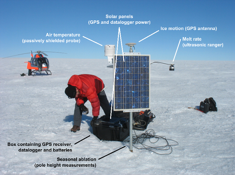
Summary
A major uncertainty associated with predictions of global sea level rise by 2100 is that we know little about how changes in climate will affect the dynamics of the Greenland and Antarctic ice sheets (IPCC, 2019). If climatic changes can cause changes to the flow of kilometres-thick ice, there could be large impacts upon 21st century sea level rise.
HI-SLIDE will measure the dynamics of high-elevation regions of the south-west Greenland Ice Sheet. In recent years we have seen meltwater running along the surface of high-elevation regions before it disappears down crevasses and moulins. Meltwater which reaches the bed of the ice sheet can change the ‘slipperiness’ of the contact between the ice and its bed, which changes the speed at which the ice flows. Previous work has shown that this does not always cause the ice to flow faster: at lower elevations, the ice flowed slower in years of more melting.
Observations of this phenomenon at high elevations are sparse. As such, current evidence of the impact of meltwater upon ice flow is equivocal. It is not clear whether the expanding runoff limit has increased or decreased ice flow at high elevations. HI-SLIDE will make the required detailed field observations to fill this gap, using a network of GPS receivers which will be installed and maintained during a 2-year field campaign from April 2020 to April 2022.
HI-SLIDE is based at the University of Fribourg in collaboration with the University of Edinburgh, and is integrated tightly with the European Research Council-funded ‘CASSANDRA’ project, ‘Accelerating mass loss of Greenland: firn and the shifting runoff limit’.