The Summer School started on Monday 17 June, with all participants and organisers meeting at the bus station in Courmayeur (Italy) at 1 pm. Leona and I arrived early, which gave us a chance to grab some focaccia and ice cream and walk around this charming mountain town.
After all participants had arrived, we met the main organisers, Simone, Massimo, and Titi, and were transported to a nearby village, La Palud, where the headquarters of the Fondazione Montagna Sicura (FMS), Villa Cameron, is located. FMS is a centre for studying climate and environmental changes in mountainous regions, focusing on safety, sustainable development, and the impact of climate change. It also serves as a training and documentation centre on mountain safety and natural risks in the Alpine environment.
The previous owner of Villa Cameron was Una Cameron, a renowned Scottish mountaineer and artist born in 1904, known for her pioneering climbs in the Alps and other mountainous regions in the early 20th century. She made significant contributions to mountaineering, including numerous first ascents, and was a trailblazer for women in this sport. After her death, the Autonomous Region of Valle d’Aosta inherited her villa for the purpose of housing a centre on mountain research. FMS was our host for the week, and all lectures and practical exercises were conducted at Villa Cameron.
We started the school with a warm welcome from the FMS director Jean Pierre Fosson, followed by lectures from Prof. Carlo Doglioni, president of the INGV (Italian National Institute of Geophysics and Volcanology), about the geological evolution of the Western Alps. After him, Prof. Franco Salerno introduced the Pyramid Laboratory (Mt. Everest, Nepal), located at 5050 m a.s.l., and the exciting research done there. After the talks, we had an aperitif on the villa’s patio with a beautiful view of the mountains. Apart from the variety of food and drinks that were served, two local DJs made sure that the patio turned into a dance floor. At first, only the organisers were brave enough to dance, but later they encouraged all participants to do the limbo.


From left to right: A walk through charming Courmayeur; Road to Villa Cameron; Local DJs on patio of Villa Cameron © Gabriela Clara Racz, all rights reserved
Tuesday was reserved for learning about UAV-based photogrammetry. We started at 8 am with Dr Fabrizio Troilo’s lecture about FMS projects focused on monitoring glaciers and permafrost in the valley. More particularly, we learned about ongoing monitoring of the debris-covered Miage Glacier and Miage Lake using photogrammetry analysis. The lake is an ice-contact lake near the southern end of the Miage Glacier. A glacier lake outburst flood (GLOF) event was documented on the 26 August 2014 at Miage Lake, causing flooding and damages to river embankments downstream. Such water discharges are considerably different from slower historical drainage events, so FMS started performing UAV photogrammetry surveys to monitor the lake. After the lecture, we went on a field trip to Miage Lake, where we had an opportunity to learn from Fabrizio, Luca, and Martina how the photogrammetry survey is done in practice. First, Fabrizio and Martina showed us how to measure precise locations of ground control points (targets marked with paint on rocks) using differential GPS (Geomarks). Afterwards, Luca showed us how to pilot the drone and plan photogrammetry flights. We had lunch at the lake and afterwards we went back to Courmayeur for data processing.


From left to right: Measuring ground control points on the moraine of the Miage Glacier, view of the Miage Lake from our lunch spot, 3D model of Miage Lake that I created in Agisoft Metashape using photogrammetry data acquired at Miage Lake. Flags represent GCPs that we measured in the field and used for georeferencing. © FMS / Gabriela Clara Racz, all rights reserved
On Wednesday, Dr Niccolò Dematteis gave a talk about proximal sensing systems, such as cameras, GNSS, robotic total stations, and GBSAR (Ground-Based Surface Deformation Monitoring Radar), used for monitoring the movement of landslides and glaciers. Niccolò showed us the interior of the time-lapse camera system that he uses (in combination with a sophisticated image correlation algorithm) to estimate daily surface displacements of the glacier surface. We, however, used it to take a group “selfie”.
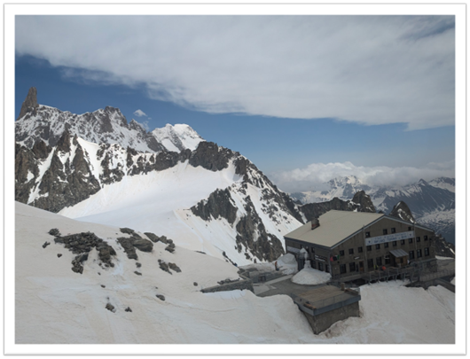
One of the highlights of the school was a visit to Skyway Monte Bianco, a state-of-the-art cable car system located in the Mont Blanc massif in Italy, connecting the town of Courmayeur to Punta Helbronner at an altitude of 3466 metres. We visited the observation deck with a view of the surrounding mountains and glaciers. We also visited Torino Hut (Rifugio Torino), a popular starting point for various mountaineering routes and excursions in the Mont Blanc massif, offering essential facilities such as sleeping quarters, meals, and a place to rest in the high-altitude environment. On our way down, we stopped at Pavillon du Mont Fréty, where we visited an Alpine botanical garden and enjoyed the stunning views.

In the afternoon, when we returned to Villa Cameron, Dr Stefano Urbini (INGV) talked about geophysical exploration of Antarctica using radio echo sounding (RES). Stefano has participated in 24 expeditions to Antarctica organised by the Italian National Antarctic Research Program (PNRA), so he had some incredible stories to share. Stefano’s research helped select the site for EPICA (European Project for Ice Coring in Antarctica), a palaeoclimatic study based on the drilling and analysis of a 3270-metres-long ice core, which has enabled a detailed reconstruction of the relationships between the percentages of greenhouse gases (CO2 and CH4) and the temperature variations of the last 900,000 years. He is also involved in the Beyond EPICA – Oldest Ice Project, which aims to find ice that is one-and-a-half-million-years old.
Thursday started with a lecture by Dr Ján Kaňuk about ice caves. Ice caves are natural underground spaces where perennial ice persists, and they often provide valuable climate records and insights into past environmental conditions. However, recently the perennial ice has been degrading, and Ján used a combination of multi-temporal LiDAR and photogrammetry surveys to track the degradation rates. In addition, he used innovative methods such as a smoke machine (like the one you see used during the first dance at someone’s wedding), in combination with thermometers, anemometer, and thermal camera, to track air circulation within the cave. We got a chance to work with some of his LiDAR and photogrammetry data to create a 3D model of the cave and to process LiDAR point clouds to estimate the degradation of ice in Jeskyně Lednická cave.
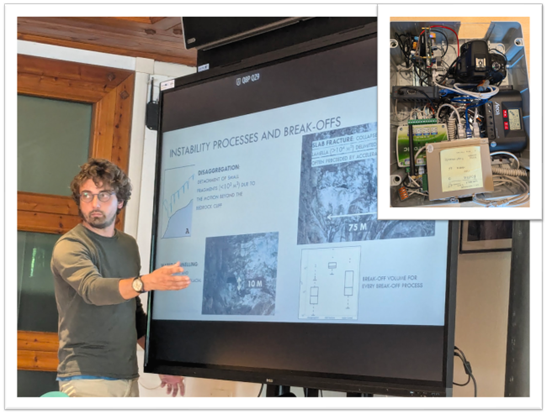
After that lecture and a hands-on processing session, we continued discussions about glacier monitoring and went to FMS’ observatory of Planpincieux Glacier, where we got a chance to see operational monitoring systems. For example, we saw a Doppler radar that can detect movement. So, in the event of an ice avalanche or ice collapse at the terminus, it will record movement and activate an alarm system, which is linked to red traffic lights and closure of the main road in Val Ferret.
After lunch, we had a short break from scientific lectures. A group of six mountain guides came and gave us a small workshop about safety in the mountains. They talked about essential things to pack in your backpack, good practices on how to stay safe, and they also showed us some basics of glacier travel and crevasse rescue.


From left to right: Ice formation and degradation on the cave floor between 2016 and 2020. Visualisation created in Cloud Compare using data provided by Dr Ján Kaňuk; Observatory of Planpincieux glacier maintained by FMS; Dr Massimo Musacchio showing students how to use spectral radiometer; Planpincieux Glacier. Zoomed-in view from the Observatory. © Ján Kaňuk / FMS / Leona Repnik / Gabriela Clara Racz, all rights reserved
The final technique we covered on Thursday afternoon was spectral radiometry. The original plan was to go to Punta Helbronner with mountain guides and collect snow and ice samples that we could analyse with a field spectral radiometer (FieldSpec). Due to bad weather, we had to stay indoors, so we tried out how the spectral radiometer works on different types of leaves, rocks, and paper. This practical component was accompanied by lectures from Dr Massimo Musacchio and Prof. Roberto Colombo about hyperspectral and thermal remote sensing of snow.
The last day was reserved for lectures from experts in various fields. Prof. Sergio Teggi gave a talk about topographic corrections in high mountain areas, and Prof. Alberto Cina introduced us to geomatic techniques. After that, we focused on applied work done at regional and national institutes such as Fondazione Montagna Sicura, Earth Observation Valle d’Aosta, and the Environmental Protection Agency. We learned about glacier monitoring of morphodynamics of the Mont Blanc glaciers and their recent evolution, using InSAR for monitoring unstable slopes and landslides, and the application of Sentinel data for water resource management and agriculture in alpine environments. These lectures really showcased how exciting and relevant research can be done outside of academia as well.
At last, after quickly packing, and almost forgetting my backpack in Villa Cameron, we had to say goodbye to Courmayeur and start our journey back home. It was truly an inspiring week immersed in the world of remote sensing and the breathtaking beauty of the Alps.
Gabriela Clara Racz is a postdoctoral researcher studying subglacial hydrology at University of Lausanne. Her participation in the International Remote Sensing Summer School in Courmayeur (Italy) was made possible thanks to the contribution from the SPI Field & Summer School funding instrument.