Tomorrow is a day I have been looking forward to for a while: Raphi and I will going to the Gornergletscher to conduct a ground-penetrating radar (GPR) survey with our AIRETH system. AIRETH is a helicopter-borne GPR platform that we re-designed in the frame of an SPI Technogrant funded by the Swiss Polar Institute and in close collaboration with both ETH’s Institute of Geophysics (Prof. H. Maurer) and ETH’s Chair of Space Geodesy (Prof. B. Soja). The result is a unique system that allows us to measure the thickness of glaciers from the air. In the case of the Gornergletscher, we are looking into how the lowermost part of the presently ice-covered terrain will look like once the glacier will have retreated. The question is of relevance because from earlier partial surveys, we know that the location is “overdeepened”, i.e. hosting a depression that will most likely fill with water and thus form a lake. And since this lake is expected to be large, the interest in it is manyfold: for one, it will be a new addition to the high-altitude landscape it is embedded in, for another, it could be a source of hazards, since avalanches, rockfalls, or other mass movements could impact it and cause the lake to overspill. Finally, there are plans to use the lake for future hydropower production, potentially playing a role in Switzerland’s renewable electricity supplies.
With this target in mind, we set off to Täsch, where we will spend the night and set up the AIRETH system to be ready tomorrow morning. The travel from Zurich takes us over Andermatt and the Furka railway tunnel to Valais. The weather is pretty marginal (in fact, the rain is literally pouring…) and, while waiting for the car transport through the railway tunnel, I think of how much trust we put in our meteorology colleagues these days. I mean, based on what the weather looks like at the moment, I would strongly bet we won’t be able to fly tomorrow, but you know, the forecast indicates otherwise and so we trust that our travel will not be in vain.
In Täsch, we have an early dinner and agree that if we want to set off at 05:00, 04:55 seems like a good time to set the alarm for. The night is not particularly great: a combination of excitement for what lies ahead, far too warm room temperatures, and the fact that I forgot that our room is located 30 metres from the train tracks that lead up to Zermatt. A train reminds me of it at 04:30, when the deafening racket briefly makes me fear that this will be the last sound I will ever hear – I quickly realise that this fear is an exaggeration.
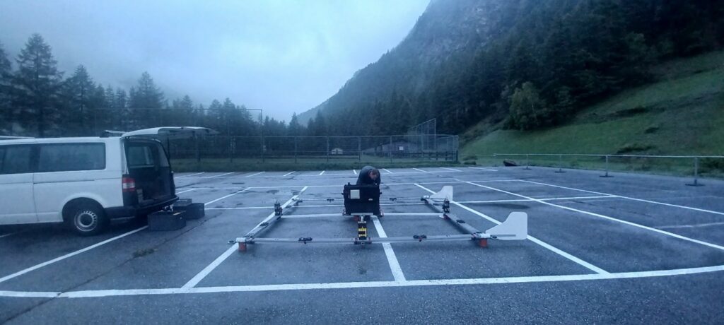
As planned, we leave our room at 05:00 and drive to the carpark to mount and test the AIRETH system. The survey flight is scheduled for 09:00, we estimate that mounting the system will take us some good 2 hours, and we want to have plenty of time in case something does not go to plan. While we mount the system bit by bit, Raphi tells me about the various thoughts he had when re-designing the system: from the materials used to produce the individual elements of the carrier frame, to the size of the bolts that keep everything together and the routing of the individual cables that connect the various pieces of instrumentation. The result is great, I think, but certainly I’m somewhat biased here!
Setting up the system goes faster than expected, and the various pre-flight system checks all run smoothly. That is great and gives us time to enjoy our breakfasts. We do so standing under our van’s open boot door, as we still need to put faith in the weather forecast: it is drizzling.
The sky eventually clears around 08:30, and a few minutes past 09:00, we hear with excitement the unmistakable sound of a helicopter approaching.
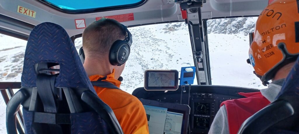
The helicopter lands next to us with a steep turn – Air-Zermatt-style, as expected. The pilot shuts down the motor, and gets off the helicopter with his assistant. The first thing they do after briefly greeting us, is to light a cigarillo. They really look like cowboys – air cowboys, of course – and for a moment I’m surprised they don’t wear cowboy boots. Their look aside, they definitively convey the impression of being at the top of their game. Similarly, they recognise that it is not the first time we operate our system either. Raphi explains the key features of the instrument – notably the ones that are relevant for the flight operation, as well as for the mission’s target and the flight plan. The pilot is happy with all our plans, and so, we are ready for take-off!
The approach flight takes us from Täsch in the direction of the Gornergrat, before plunging towards the tongue of the Gornergletscher at the level of the Gornersee. From there on, we are in survey mode: the GPR is continuously firing electromagnetic pulses that are reflected at the interfaces of materials with different properties, such as those at the surface of the glacier when the signal transitions from air to ice, or at the glacier base when the signal hits the underlying bedrock or subglacial sediment layers after having travelled through the glacier’s ice. This is the signal we are most interested in and the display we have onboard the helicopter provides us with first indications for what the signal quality is going to be.
The survey foresees a series of longitudinal and across-glacier profiles. These are planned ahead and the pilot sees them on his screen. Nevertheless, the manoeuvring requires the pilot’s full concentration, as he is flying on sight. On top comes the fact that for the signal quality, the closer we are to the ground, the better it is – with the problem that the GPR system is dangling as a swing about 15m below us, making it slightly difficult to gauge the actual distance between the ground and the system, especially on uneven terrain such as the lower parts of the Gornergletscher.
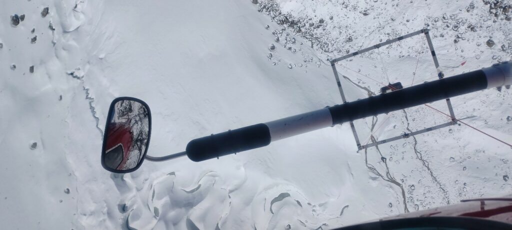
To help with this challenge, and to maximise the safety of our operations, we are testing a new piece of equipment: it is a little display that can be mounted on the helicopter’s instrument panel inside the cockpit, and that displays the distance-to-ground in real time. It is supported by an acoustic system, that beeps at different intervals depending on the distance – much as we are used from car parking aids. So far, we were reading out the information from the onboard laptop, which meant that the pilot would constantly have our voices in his headset – something that must have been nerve-wracking for the pilot, I guess!
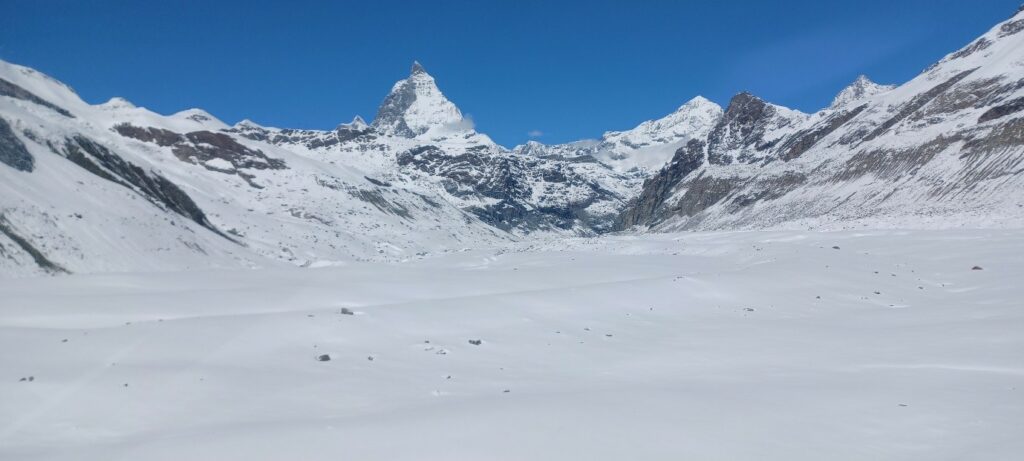
The flight is very smooth, and whenever possible, we take a moment to look out the helicopter windows. Our faith in our meteorology-colleagues has grown further, as they were right in forecasting an absolutely beautiful day. The fact that the Matterhorn dominates one side of the view while the other side is taken by the glaciers in the Monte Rosa massif, clearly don’t make the day any less beautiful.
After two hours of flight, our survey is complete. That seems to be good timing, as the pilot briefly comments on the fact that we are starting to run somewhat low on fuel. So, we return to Täsch, our starting point. The helicopter crew just drops us and proceeds to their next mission, while we are left saving all data and dismantling the AIRETH-system again. Raphi and I are both totally happy, as the survey went as smoothly as it possibly could have. On top of that comes the fact that, at first glance, the data look very promising. The data processing that lies ahead will tell if this first impression is correct but for now, we can call it a day. We are left with journey back home with a pizza planned along the way – this time not worrying nearly as much about whether meteorologists might be right about tomorrow’s forecast. They have earned our trust anyway.
Daniel Farinotti is the Head of the Professorship of Glaciology at both the Laboratory of Hydraulics, Hydrology and Glaciology (VAW) at ETH Zurich and the Swiss Federal Institute for Forest, Snow and Landscape Research (WSL). Raphael (Raphi) Moser is the lead technician in Farinotti’s group, certified mountain guide, and the main operator of the AIRETH system. The field survey took place in May 2024 with the financial support of an SPI Technogrant.